
Samuel and Johanna (Purcell) Christian - Family Reunion
/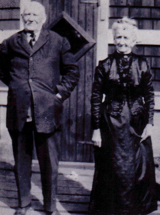
Samuel and Johanna (Purcell) Christian
Read MoreSamuel and Johanna (Purcell) Christian
Read MoreBetween 2000 and 2002 the late Doug Grant and Ed Rogers worked together to develop the amazing land grant maps that are showcased on this website. They have been a huge resource for people undertaking land and genealogical research.
Though the maps of Doug and Ed put the puzzle pieces of land together a lot of people have never seen the original grants. Below is an example of the maps that Doug and Ed used to create their digital version of the land grants at Prospect.
This grant map is for a piece of land that James Coolen purchased in 1879 for thirty dollars. As you can see the piece of land which today is located in the stretch of road between the Old and New cemeteries on the hill overlooking the Barrasois.

Nova Scotia Archives, Halifax County Land Grants, 1854-1957, vol. 4, p. 220, no. 12893, Land Grant of James Coolen, fisherman, Prospect.
This plot of land has, of course, today been sub-divided into smaller plots, especially along the road where houses have been purchased.
You can view these land grants and more on www.familysearch.org.
Social media websites such as Facebook are a great way for people to share photos and there are plenty of Pages on these websites for people who like looking at old photos and remembering what things used to look like.
The other day a photo by George Hunter was posted to one such group by a Gary Merrick. The photo was attributed to Hunter and dated 1959 (see below).
Its a great photo because it captures a lot of homes that are no longer present in the village, as well as a good shot of what was Christian’s factory but was known as Victor’s Wharf when I was a child. This large multi story cannery was built in the 1880s and stood till 1996 when it was blown over in a Hurricane.

This is a really great photo as it shows this part of the village before a lot of the houses were changed in the 1960s and 1970s. You can see the original house on Saul’s Island. Just above the roof line of the Church Hall is a small house owned by Mary Saul, this was replaced in the 1970s with a more modern house that still stands today. Next to that is the home of Olive Ryan, which again was torn down in the late 1990s and replaced with a much larger modern home. Similarly, the home just adjacent to the Christian Factory has been modified into a more modern home.
After much delay (2 years) we have finalized the transfer of content from the old website to the new website. This means that the content that existed in 2016 when we moved servers has now been entirely updated.
Our next steps over the next few weeks is to begin adding new content - including hundreds of new photos that have been donated to the website over the last few years.
-Nat
The Prospect Genealogical Website has been online since 1998 and over the course of that time I have researched every aspect of life in the village.
As the website is updated to get the original content back online, and new information and photos is added I hope to use this blog to present some of the research in snippet form.
The picture that I have chosen for the Banner above was taken by Matt Madden Photography of Halifax.
Enjoy
Nat
Copyright 2024 The Prospect Genealogical Website